Show Point
The Show Point function can display the point co-ordinates and code on the screen.
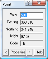
Point
To choose the point, you can click on a point on the screen, or enter the point number at the keyboard.
Type in the point number and press ENTER or TAB to fetch and display the point co-ordinates.
Easting
Every point must have a Easting (X) value. It is stored to more than 6 decimal places but only
displayed to three decimal places. You can see the Easting (X) value for the mouse displayed
in the bottom left of the screen as you move the mouse.
Northing
Every point must have a Northing (Y) value. It is stored to more than 6 decimal places but only
displayed to three decimal places. You can see the Northing (Y) value for the mouse displayed
in the bottom left of the screen as you move the mouse.
Height
The height (Z) value for the point is optional. If a point has no height value, this field will be blank.
Computed points like lot corners will generally not have a height value.
The height value is stored to more than 6 decimal places but only displayed to three decimal places.
Code
The point code is a text string which is associated with the point. Generally this will be entered
during the field survey to indicate what type of point feature is being measured. e.g. a code ‘FC01’
may be used to tag a point on a fence line (fence line 1). The code can consist of alpha and numeric
characters, it can be of any length, but generally is less than 10 characters long.
There is also a point Description in the Properties that can be used for a longer point description.
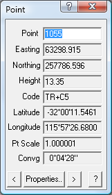
The following fields are displayed if a Datum has been specified.
Latitude
The latitude of the point is derived from the Northing using the specified Datum and Zone.
Longitude
The longitude of the point is derived from the Easting using the specified Datum and Zone.
Point Scale
The Point Scale is derived using the specified datum and Zone.
Convergence
The Convergence is derived using the specified datum and Zone.
Properties
For more details on the point properties, press the Properties.. button.
For more information about point properties see the Point Properties section.
Arrows
The left, right arrow keys can be used to display the previous point or next point as required.